
Typhoon Domeng Influences Weather Across Philippines
Typhoon Domeng and Southwest Monsoon bring scattered rains, thunderstorms to La Union.
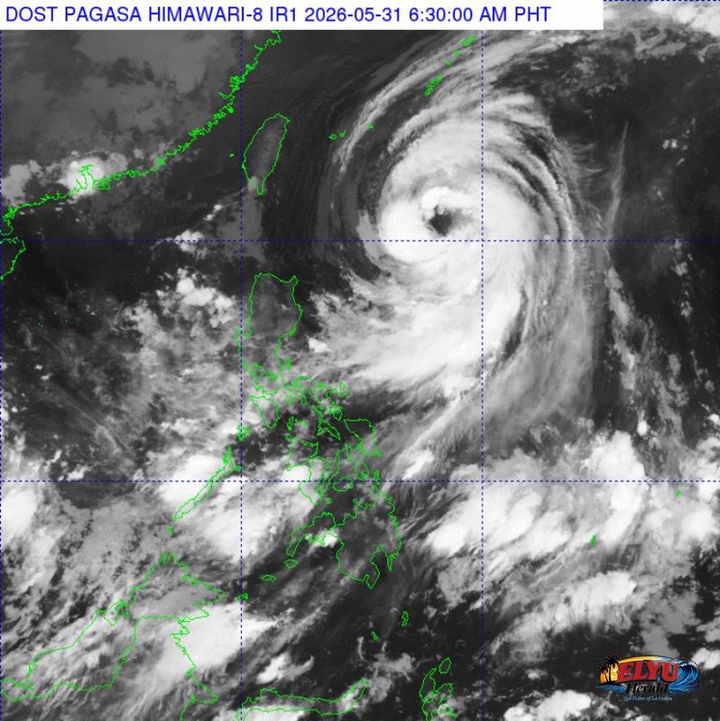
Screenshot from PAGASA's Himawari-8 viewer, credit DOST-PAGASA
According to PAGASA, Typhoon “DOMENG” {JANGMI} was located 670 km East of Basco, Batanes, as of 3:00 AM today, May 31, 2026. The typhoon carries maximum sustained winds of 120 km/h near its center and gustiness of up to 150 km/h, moving North Northwestward at 20 km/h, while the Southwest Monsoon continues to affect Southern Luzon, Visayas, and Mindanao.
The weather bureau forecasts cloudy skies with scattered rains and thunderstorms for Metro Manila, CALABARZON, Bicol Region, MIMAROPA, Western Visayas, Negros Island Region, Zamboanga Peninsula, and BARMM due to the Southwest Monsoon. Residents in these areas should prepare for possible flash floods or landslides from moderate to heavy rains.
Central Luzon, Cagayan, and Isabela are also expected to experience cloudy skies with scattered rains and thunderstorms, influenced by the trough of Typhoon Domeng. This could lead to flash floods or landslides from moderate to at times heavy rains. The Ilocos Region and La Union will have partly cloudy to cloudy skies with isolated rainshowers or thunderstorms, with localized thunderstorms potentially causing flash floods or landslides.
Coastal waters in Northern Luzon and La Union will be moderate to rough, with wave heights ranging from 1.2 to 3.4 meters, driven by moderate to strong winds from the Northeast to Northwest. Fisherfolk in ELYU Coastal municipalities like Agoo, Bauang, San Fernando, San Juan and Bacnotan are advised to exercise caution.
Central Luzon will see slight to moderate coastal waters (0.6 to 2.5 meters) with light to moderate winds. The rest of the country will also experience slight to moderate coastal waters.
SOURCE: PAGASA